|
#412
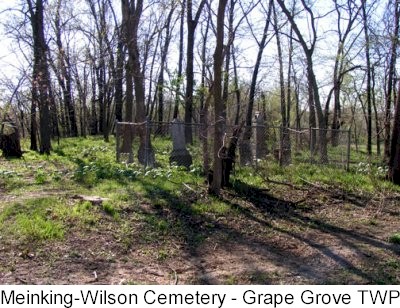
Meinking-Wilson Cemetery Grape Grove Township |
||
Ray County Cemeteries - Web Page
|
#12 on Grape Grove Township Map |
||||
| Meinking-Wilson Cemetery
aka Cox Cemetery |
Latitude: 39°21'30.00"N Longitude: T53R26S34; NE1/4 SE1/4 |
#12 on Grape Grove Township Map |
Cemeteries of Grape Grove Twp: Meinking-Wilson Cemetery is on south side of route 'AA'; 3/4 miles east of route 'A'; located in a grove of trees near the road; about 13 marked graves (1989)
Big black Cemetery binder at Ray County Library: Cox Cemetery is on private property. Located in wooded area on south side of Route AA approximately 3/4 miles east of Route A on Lamar Carpenter property in NW 1/4, SE 1/4, Sec 34, Twp 52N, Rng 26W, Crooked River Twp. this area very well kept. [county coordinator comment: even though it says Crooked River Twp, these coordinates would place it right at Meinking-Wilson Cemetery in Crooked River Twp] Ray County History 1973, p. 232 Cemeteries Not Listed on Map, #24: Cox Cemetery is on south east part of James Bowman farm, Route AA DAR Index: Meinking/Wilson (Cox) Cemetery is located about 3/4 miles east of Route A, on Route AA on the south side of the road in a clump of trees |
Cemeteries of Grape Grove Township, January 1995; compiled by Al McKemy, Mar 1989 | MC 977.819 M195c AFRA | |

photo submitted by Jennifer Zunker |
Transcription:
Ray County Home Page | MoGenWeb | USGenWeb | WorldGenWeb | E-Mail County Coordinator
To add additional information relating to Ray County, Missouri Genealogy, E-Mail the county coordinator.
since November 11, 2006
Last Updated