|
 |
|
|
|
|
#409
Berry Cemetery Grape Grove Township |
||
Ray County Cemeteries - Web Page
|
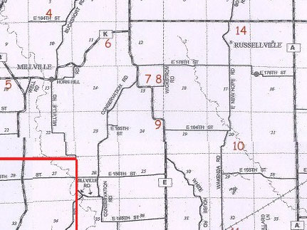
#9 on Grape Grove Township Map |
 |
||
| Berry Cemetery |
#9 on Grape Grove Township Map 2005 Ray County Plat Book, p. 28 Section 24 |
Latitude: 39°23'29"N; Longitude: 93°52'16"W
T53R27S24 |
on Route 'E' about 0.5 miles north of county road 152; in a timber on south side of road; L. Lam property
5 marked graves (1994); 4 stones together; older stone south side of timber; probably more burials. typed sheet at Ray County Library (in black binder 929.3 RAY): Route #P [Hwy E] on a curve that bends west. Just around the corner and on the south side is only 4 marked graves. It has grown up with weeds and shrubbery. The cemetery sits close to the road. LS notes: south of Doug Lam's house on blacktop on curve - in brush on south side of the road |
Cemeteries of Grape Grove Township, January 1995; compiled by Al McKemy, 30 May 1994 | Ray REF 929.3 RAY
MC 977.819 M195c AFRA |
|
Transcription:
Ray County Home Page | MoGenWeb | USGenWeb | WorldGenWeb | E-Mail County Coordinator
To add additional information relating to Ray County, Missouri Genealogy, E-Mail the county coordinator.
since November 11, 2006
Last Updated