|
 |
|
|
|
|
#830
Gunnell - Murray Cemetery Richmond Township |
||
Ray County Cemeteries - Web Page
|
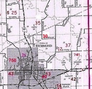
#30 on RichmondTownship Map |
|||
| Gunnell-Murray Cemetery
(aka Murray, Gunnell, Smith Cemetery) |
#30 on RichmondTownship Map |
Latitude: 39°18'26.00"N Longitude: T52R27S20 ne1/4nw1/4 |
Ray County History 1973, p. 232: Cemetery is not listed on Map, #3; on W.G. Calvert farm
The Gunnel Cemetery is located in the ne corner of nw 1/4 T52R27S20. Located on land owned by Guy Murray (2001) Direction: from Hwy 13 just north of the Richmond City Limits take 116th Street east to Wood Oak Road then north to 120th Street then east to Derstler Road then south to 118th Street east 1/4 mile to drive. Ray County Library (big black cemetery binder): North on Highway 13 across bridge at edge of town. Turn right on first gravel road after bridge. Garage on left side of road. Go about one mile to T. Turn right and go to first driveway. Turn left in driveway and go to house on top of hill. Cemetery is north and west of the house. --- DAR Index: east of Hwy 13 on 116th Street to 120th Street, then right on 118th Street for 7/10 miles. Cemetery is on the north side of the road. --- Located on land owned by Guy Murray. (2001) Listed by Margaret Arnold and Pauline E. Brown, November 5, 1987, with Mary Orr, daughter of Guy Murray, above. Located northeast of Richmond, north of the Calvert towers --- It is approximately 80 Ft. north and south by 75 Ft. east and west The earliest dated marker is 1842. for more information email Guy R. Murray |
listed in Thurman Funeral Home Records book |
Transcription:
Ray County Home Page | MoGenWeb | USGenWeb | WorldGenWeb | E-Mail County Coordinator
To add additional information relating to Ray County, Missouri Genealogy, E-Mail the county coordinator.
since November 11, 2006
Last Updated