|
 |
|
|
|
|
#608
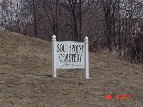
South Point Cemetery Orrick Township |
||
Ray County Cemeteries - Web Page
|
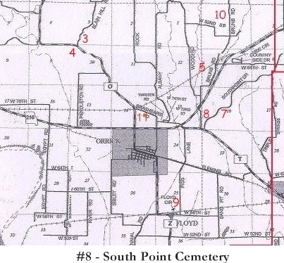
#8 on Orrick Township Map |
|||
| South Point Cemetery | Orrick Twp
#8 on Orrick Township Map |
Latitude: 39°13'24.00"N Longitude: |
1973 Ray County History: The land for the oldest part of this cemetery was donated by a Mr. Ross in 1844. Later, land was obtained from Dr. William H. Campbell.
May 1941 The South Point Cemetery Association was formed. The affairs of the association were to be managed by a board of trustees consisting of six members. The first were - Mrs. Lora Offutt, president; C. A. Gooch, vice-president; Mrs. Edith Hendrix, secretary; Arch Kirkham, treasurer; Mrs. Mary Sheetz, and E. A. Paulson. In 1965 the listings of the cemetery showed over 720 graves. The first was that of Lewis Pigg, February 8, 1783-Apirl 5, 1845. The people of the Orrick Community are proud of this cemetery which is well kept. It is located on a peaceful and serene hill-top, one and one half miles east of Orrick on Highway 210 and one-fourth mile north on Route E. (1973 - roads have changed since then) --- DAR Index: located at Hwy T and Hwy EE (Southpoint Drive) --- It has been observed that in old obituaries when the place of burial is said to be: "in the cemetery at South Point Church", the burial is actually in Brasher Cemetery and not at South Point Cemetery. |
Ray REF 929.3 RAY |
South Point Cemetery Will Observe '42 Decoration Day
Ray County Home Page | MoGenWeb | USGenWeb | WorldGenWeb | E-Mail County Coordinator
To add additional information relating to Ray County, Missouri Genealogy, E-Mail the county coordinator.
since November 11, 2006
Last Updated