|
Ray County Genealogy Home Page |
 |
|
|
Ray County Genealogy Home Page |
|
|
Woolard Cemetery
|
||||||||
 |
||||||||
| Name of Cemetery | Woolard Cemetery | |||||||
| Township | Grape Grove Twp | |||||||
| Cemetery # | #410 | |||||||
| Alternate Names | Wollard Cemetery; Woollard Cemetery; aka Prichard Cemetery [see CC comments]; possible also called Rice Cemetery | |||||||
| Latitude/Longitude | Latitude: 39°22'37"N; Longitude: 93°50'7"W | |||||||
| Township/Range/Section |
T53R26S29; NE1/4 |
|||||||
| Cemetery Still in Use | No | |||||||
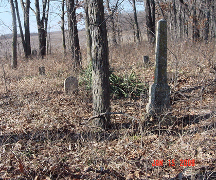
| Size of Cemetery | about 30 known burials, probably more | |||||||
| Condition | in the middle of some tall trees; easily viewed when the vegetation is not growing; probably overgrown during the summer | |||||||
| Range of Burial Dates | ||||||||
| Oldest Known Stone: | Newton Evans d. August 14, 1837; Nancy J. Woolard d. January 2, 1854 |
|||||||
| Last Known Burial | death certificate for Mary W. Jacobs d. January 5, 1916 [death certificate indicates she was buried in Rice Cemetery, but Woolard Cemetery transcription indicates she was buried in this cemetery and there is a stone in Woolard Cemetery] |
|||||||
| Visited yet? | CC - yes................ JZ - yes/no...........anyone else - yes | |||||||
| Location/Directions/Comments | ||||||||
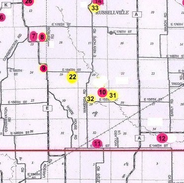
| Most recent directions | From the intersection of Hwy "A" and East 155th Street, travel west on East 155th Street 1 mile. [Or 7/10 miles west of the intersection of Wakenda Road and East 155th Street.] Just before this point, the road turned slightly north and then back west. Turn into the field just west of the tree line. Follow the grass farm path along the tree line for about 500 yards. The cemetery is in the trees on the east side of the path almost directly east of the farm pond that is about 100 yards west of the path. If the field is dry, you can probably drive to this point otherwise it would be better to walk.
It is better to visit this cemetery in the winter. If you are looking for this during the summer you will not see a pond in the field as the corn will be obsuring it. Instead, look for a grouping of trees in the center of the field of corn - that is where the pond is and eye a line directly toward the tree line from the "point of trees". The area in the summer is so overgrown, that it may take a long time to find it. |
|||||||
| 1973 Ray County History; p. 230 | #11 Prichard Cemetery | |||||||
| 1973 Ray County History; p. 232; Cemeteries Not Listed on Map | #xx; description | |||||||
| Big Black Cemetery Binder | located on Clara Allison farm 1 mile west of B Highway and 8 miles north of Hardin, Missouri, on B Highway[???] | |||||||
| Cemeteries of Grape Grove Township by McKemy |
from intersection of county road 146 and 148 go north on county road 146 0.6 miles to jog in road; continue east in field along timber about 1/2 mile; private property; small abandoned cemetery has very little care |
|||||||
|
Ancestry.com |
xxxx |
|||||||
|
DAR Index: |
"Wollard" Cemetery aka Prichard Cemetery located in Grape Grove Twp. From 155th Street north on Wakenda Road, 6/10 mile to jog in road. Continue east in field along timber about 1/2 mile. |
|||||||
| LS info | xxx | |||||||
| Other Comments |
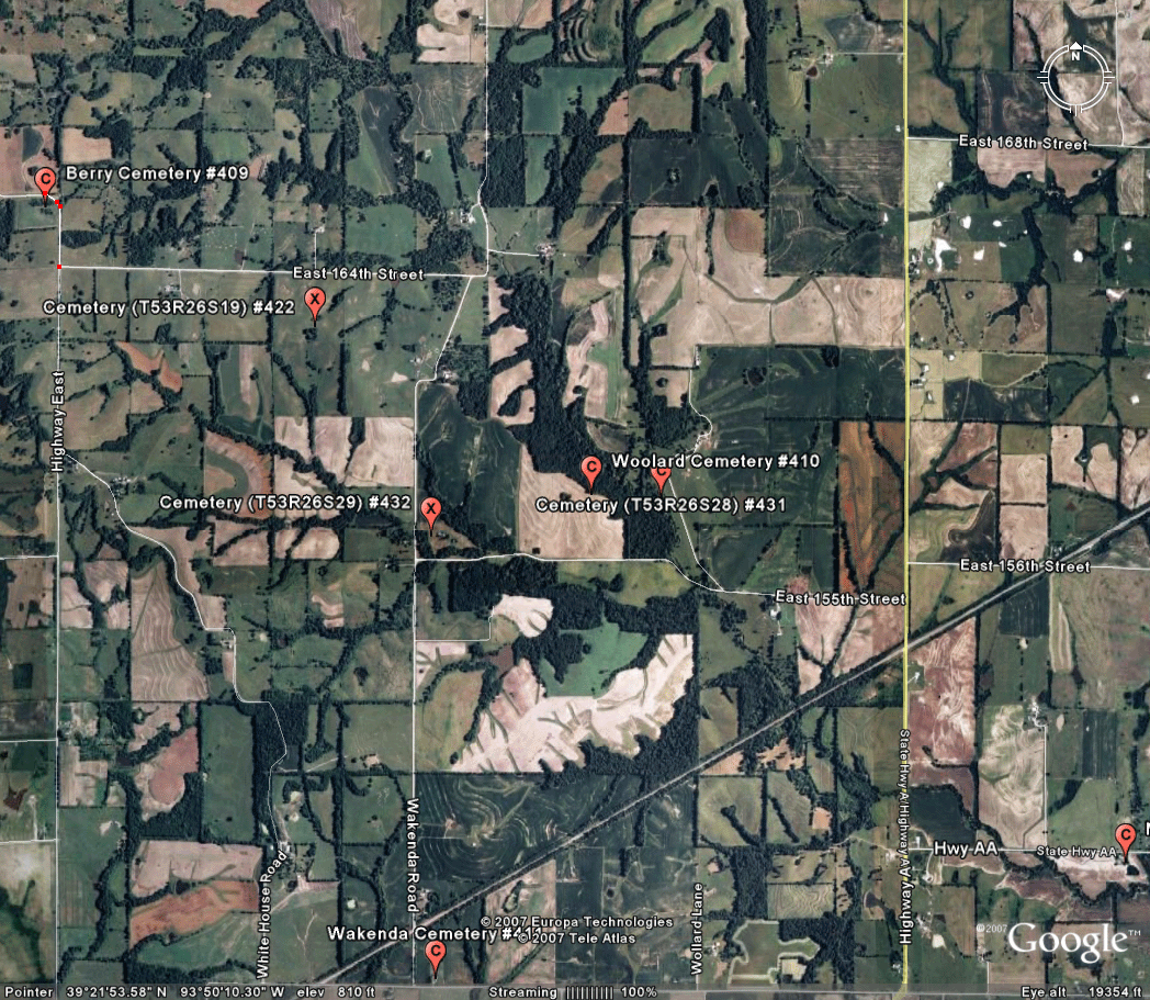
Connie Linter spoke with the Hardin city clerk and land owner and was able to obtain directions and visit the cemetery. Traveling West on 155th from Hwy A, you pass by a farm with a long driveway, cross a creek, navigate an "S" curve, then as you pass a patch of timber on the North side of the road you will see an old grassed-in farm road along the timber. Turn North into the field and travel along the timber, in a general Northwesterly direction, until you see a pond in the middle of the field. The Cemetery is in a "point" of timber just northeast of the pond. It has been indicated by some sources that the location is T53R26S20 SW1/4SE1/4. The cemetery is actually located at T53R26S29 (NE1/4) The 1877 plat map indicates there is a cemetery (#31) marked in T53R26S28 which is probably this cemetery. It is still believed that cemetery T53R26S29 (#32) is a different cemetery. death certificate of John Hall indicates he was buried in Rice Burying Ground, date of death April 10, 1910; he is NOT listed in the Woolard Cemetery transcription |
|||||||
| Plat Maps | year | marked? | who's land? | |||||
| T53R26S29 | 1877 | no (a cemetery is marked in section 28; possible this one? but marked in wrong section?) | C. P. Wollard | |||||
|
1897 |
no | J. M. Pugh | ||||||
| 1914 | no | Hulda Pugh | ||||||
| 1930 | no | H. F. Pugh | ||||||
| 1970 | no | Monroe Allison | ||||||
|
1976 |
no | Monroe P. Allison | ||||||
| 1997 | no | Jack Waller | ||||||
| 2005 | no | Jack Waller | ||||||
| Transcriptions online: | ||||||||
| GTT online | ||||||||
| Ray County Archives | ||||||||
| Ancestry.com | ||||||||
| Find-A-Grave | ||||||||
| Other Online Link | ||||||||
| Compilations | Cemeteries of Grape Grove Township, January 1995; compiled by Al McKemy, 4 Apr 1993 | |||||||
| Library References | ||||||||
| Genealogical Library - Ray County Museum | ||||||||
| Ray County Library - Richmond |
Ray REF 929.3 RAY (Wollard) |
|||||||
| Mid-Continent Library | MC 977.819 M195c AFRA (Woolard) | |||||||
| Family History Library (FHL) | ||||||||
| Lookups | xxxx | |||||||
| Ray County Cemetery Project Volunteers | ||||||||
To add additional information relating to Ray County, Missouri Genealogy, E-Mail the county coordinator.
Ray County Home Page | MoGenWeb | USGenWeb | WorldGenWeb | E-Mail County Coordinator
To add additional information relating to Ray County, Missouri Genealogy, E-Mail the county coordinator.