|
Ray County Genealogy Home Page |
 |
|
|
Ray County Genealogy Home Page |
|
|
Nuckles Cemetery
|
||||||||
 |
||||||||
| Name of Cemetery | Nuckles Cemetery | |||||||
| Township | Grape Grove Twp | |||||||
| Cemetery # | #406 | |||||||
| Alternate Names | Roberts Cemetery, Nuckols Cemetery | |||||||
| Latitude/Longitude | Latitude: 39°24'59"N; Longitude: 93°53'53"W | |||||||
| Township/Range/Section |
T53R27S11; SW1/4 NE1/4 |
|||||||
| Cemetery Still in Use | No | |||||||
| Size of Cemetery | about 17 known graves
Copied by David L. Ballew (1976): The southwest corner is where the black population is buried. No stones but about 20 or more sunken places are there. The cemetery is much larger than the listing, leading the transcriber to believe there were lots of people buried there with no stones. |
|||||||
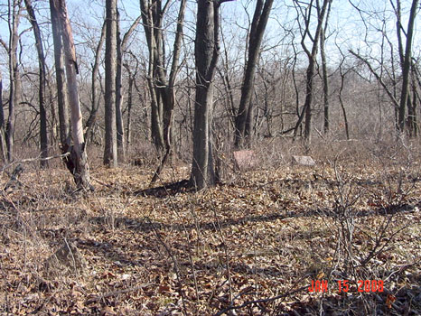
| Condition | not maintained, in the middle of a wooded area | |||||||
| Range of Burial Dates | ||||||||
| Oldest Known Stone: | Mary Thompson d. September 16, 1852; road sign indicates it was established in 1846 | |||||||
| Last Known Burial | Matthew D. Cowsert d. July 17, 1922 | |||||||
| Visited yet? | CC - yes................ JZ - yes...........anyone else - yes | |||||||
| Location/Directions/Comments | ||||||||
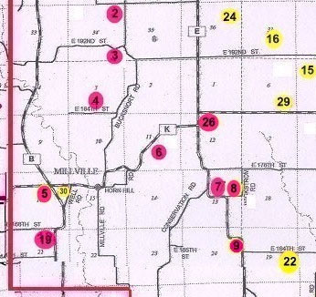
| Most recent directions | From the intersection of Highway "E" and Highway "K", travel west on Highway "K" 8/10 miles. The road is running northeast to southwest at this point. There is a "Nichols Cemetery" green sign on the east side of the road. Park near this sign. Walk straight east from the road as close to the tree line as possible. As you approach the trees, try to walk as close to the fence row as possible. Keep walking thru the woods to the cemetery at the top of a small hill. Cemetery is probably only about 200 yards from the highway, but is not visible because of the heavy vegetative growth. | |||||||
| 1973 Ray County History; p. 230 | #x, name Twp | |||||||
| 1973 Ray County History; p. 232; Cemeteries Not Listed on Map | #xx; description | |||||||
| Big Black Cemetery Binder | Located just east of Millville, on the old Renfro farm. It is about 100 yards south of the main road. There is no main road back to it. | |||||||
| Cemeteries of Grape Grove Township by McKemy | On route 'K' 0.8 miles west of route 'E'; south side of road about 13 marked graves (1976); cemetery is in horrible shape - all grown over with weeds | |||||||
|
Ancestry.com |
xxxx |
|||||||
|
DAR Index: |
Take Route K 8/10 miles, then west on Route E |
|||||||
| LS info | SE1/4NW1/4 - 9/10 miles west of Route E; across from Fedders house; 2nd house west of Billy Coats where the high line crosses the road, then east of the road in a field; on Sherri Kirk's property (formerly Misel); an old abstract says that 1 acre was given for a cemetery | |||||||
| Other Comments | On the walk to the cemetery, the woods is heavily overgrown with vegetation, so it is best to visit this cemetery when the vegetation is dormant. | |||||||
| Plat Maps | year | marked? | who's land? | |||||
| T53R27S11 | 1877 | no | Shaw or I. Mansur | |||||
|
1897 |
no | C. L. Renfro | ||||||
| 1914 | yes | C. L. Renfro | ||||||
| 1930 | no | C. L. Renfro | ||||||
| 1970 | no | H. Renfro & M. Pinkerton | ||||||
|
1976 |
no | Mary L. Pinkerton | ||||||
| 1997 | no | Stephen Kirk | ||||||
| 2005 | yes | Stephen Kirk | ||||||
| Transcriptions online: | ||||||||
| GTT online | ||||||||
| Ray County Archives | ||||||||
| Ancestry.com | ||||||||
| Find-A-Grave | ||||||||
| Other Online Link | ||||||||
| Compilations | Copied by David L. Ballew (1976)
Cemeteries of Grape Grove Township, January 1995; compiled by Al McKemy, 1976 |
|||||||
| Library References | ||||||||
| Genealogical Library - Ray County Museum | ||||||||
| Ray County Library - Richmond | ||||||||
| Mid-Continent Library | MC 977.819 M195c AFRA | |||||||
| Family History Library (FHL) | ||||||||
| Lookups | ||||||||
| Ray County Cemetery Project Volunteers | ||||||||
To add additional information relating to Ray County, Missouri Genealogy, E-Mail the county coordinator.
Ray County Home Page | MoGenWeb | USGenWeb | WorldGenWeb | E-Mail County Coordinator
To add additional information relating to Ray County, Missouri Genealogy, E-Mail the county coordinator.