|
 |
|
|
|
|
#416
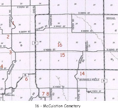
McCuistion Cemetery Grape Grove Township |
||
Ray County Cemeteries - Web Page
|
#16 on Grape Grove Township Map |
 |
||
| McCuistion Cemetery |
#16 on Grape Grove Township Map |
Latitude: 39°26'30.00"N Longitude: 93°51'18.00"W estimated T54R26S31; SE1/4 SE1/4 |
Cemeteries of Grape Grove Township: on county road 106; 2.1 miles west of route 'A'; 1/4 mile north of road; private drive; 10 marked graves (1976) [Road 106 is possibly 192nd Street today]
Ray County Library (big black cemetery binder): 1 mile north of the old log cabin then 2 miles west and then .4 of a mile back north in a field on the Charles Penny farm [1976]. The cemetery is just west of the farm house. (Township 54 Range 27 Section 36??? 1 mile east of Route P, north side of road [handwritten note, this is different than above?] DAR Index: located on 192nd Street, go 2.1 miles west of Route A. Cemetery located 1/4 mile north of road on private drive. |
Cemeteries of Grape Grove Township, January 1995; compiled by Al McKemy, 1976 | MC 977.819 M195c AFRA | |
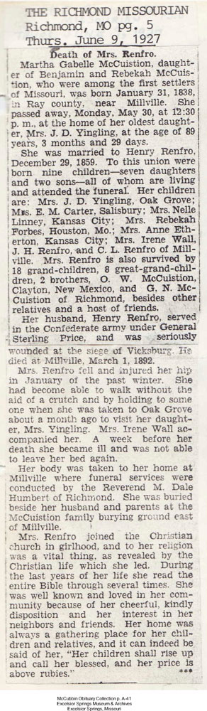
| obit of Martha Gabelle (McCuistion) Renfro
|
||
Transcription:
Ray County Home Page | MoGenWeb | USGenWeb | WorldGenWeb | E-Mail County Coordinator
To add additional information relating to Ray County, Missouri Genealogy, E-Mail the county coordinator.
since November 11, 2006
Last Updated