|
Ray County Genealogy Home Page |
 |
|
|
Ray County Genealogy Home Page |
|
|
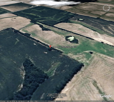
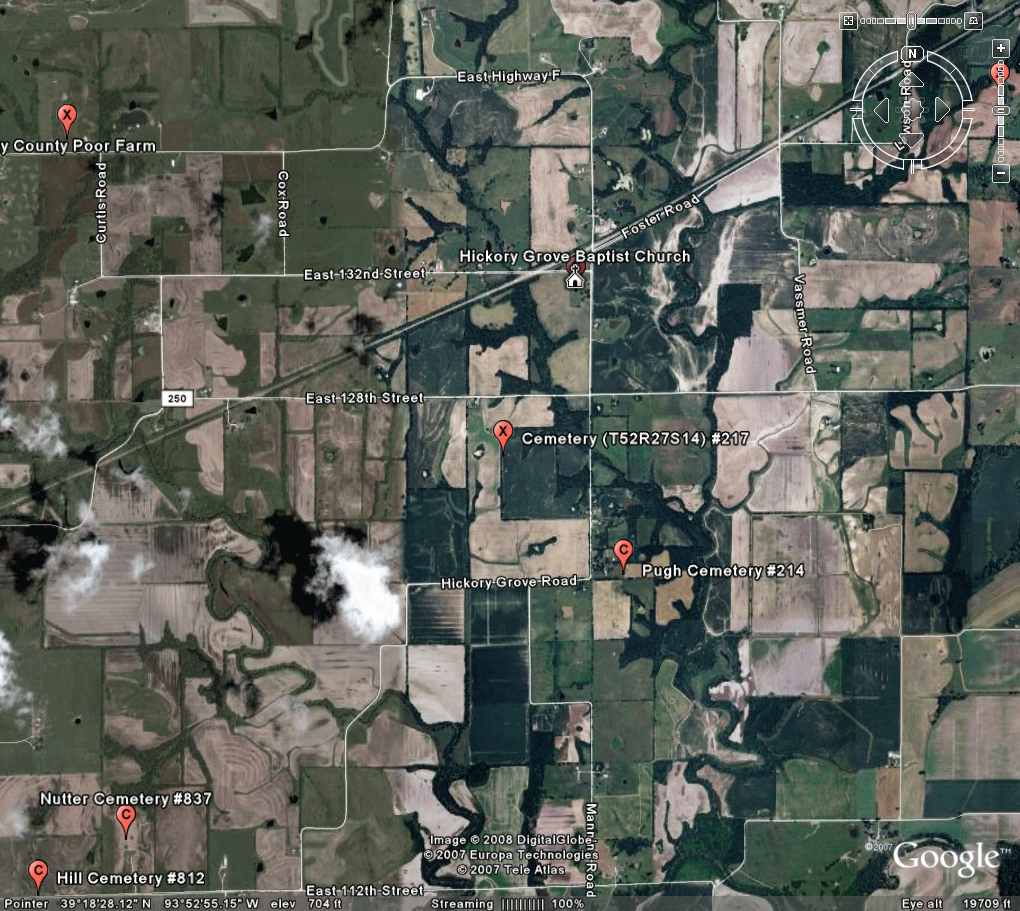
T52R27S14 Cemetery
|
||||||||
 |
 |
|||||||
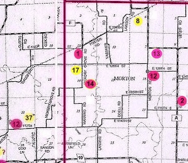
| Name of Cemetery | T52R27S14 Cemetery | |||||||
| Township | Crooked River Twp | |||||||
| Cemetery # | #217 | |||||||
| Alternate Names | xxx | |||||||
| Latitude/Longitude | Latitude: 39°19'9"N; Longitude: 93°54'22"W | |||||||
| Township/Range/Section | R52R27S14; 1/4 SW of 1/4 NW | |||||||
| Cemetery Still in Use | No | |||||||
| Size of Cemetery | the site is about 25 feet by 25 feet | |||||||
| Condition |
This information was submitted by Dean Stransky, a Resource Conservationist for the Natural Resources Conservation Service: During a field survey to layout a new terrace system, a small group of headstones was found which may be an old family cemetery. I have attached a aerial photo with the location of the stones marked and photos of three of the stones. There are four stones and what may be the remnants of a base. One of the stones is very small and could be either a foot stone or infant stone. One stone is approximately 3 feet in height and 18 inches in width and is leaning against an old fence post. The other two stones are on the ground and may be parts of the same stone. The stone against the fence post, I can make out the outline of bible but I do not have any names from any of the stones. At the time of the field investigation, I did not have the tools to make any tracings from the stones. There are marks on the stones but I was unable to make out the letters. There is what may have been a fence around the site so we did believe there are any other graves in the area. We also could not find any depressional areas that may indicate grave sites. This site was not indicated on our maps so thought it should be reported to you. |
|||||||
| Range of Burial Dates | ||||||||
| Oldest Known Stone: | xxxx | |||||||
| Last Known Burial | xxx | |||||||
| Visited yet? | CC - yes/no................ JZ - yes/no...........anyone else - yes | |||||||
| Location/Directions/Comments | ||||||||
| Most recent directions | The site is in a fence line about 1250 feet from 128th St. The fence line widens at the site. | |||||||
| 1973 Ray County History; p. 230 | xxx | |||||||
| 1973 Ray County History; p. 232; Cemeteries Not Listed on Map | xxx | |||||||
| Big Black Cemetery Binder | xxx | |||||||
| Cemeteries of Grape Grove Township by McKemy | ||||||||
|
Ancestry.com |
xxxx |
|||||||
|
DAR Index: |
xxx |
|||||||
| LS info | xxx | |||||||
| Other Comments |
|
|||||||
| Plat Maps | year | marked? | who's land? | |||||
| R52R27S14 | 1835 | "Original Land Entries", page 74 John S. Wilkerson bought the land October 13, 1835; T52, R27, S14 sw 1/4 of NE 1/4 | John S. Wilkerson | |||||
| 1877 | no | J.G. Byram | ||||||
|
1897 |
no | W.M. Byram | ||||||
| 1914 | no | W.M. Byram (B.O. Mason) | ||||||
| 1930 | no | B.O. Mason | ||||||
| 1970 | no | Glenda Hicks | ||||||
|
1976 |
no | Glenda E. Mason Hicks | ||||||
| 1997 | no | Glenda Grafton | ||||||
| 2005 | no | Christoperh Macey | ||||||
| Transcriptions online: | ||||||||
| GTT online | ||||||||
| Ray County Archives | ||||||||
| Ancestry.com | ||||||||
| Find-A-Grave | ||||||||
| Other Online Link | ||||||||
| Compilations | xxxx | |||||||
| Library References | ||||||||
| Genealogical Library - Ray County Museum | ||||||||
| Ray County Library - Richmond | ||||||||
| Mid-Continent Library | ||||||||
| Family History Library (FHL) | ||||||||
| Lookups | xxxx | |||||||
| Ray County Cemetery Project Volunteers | ||||||||
To add additional information relating to Ray County, Missouri Genealogy, E-Mail the county coordinator.
Ray County Home Page | MoGenWeb | USGenWeb | WorldGenWeb | E-Mail County Coordinator
To add additional information relating to Ray County, Missouri Genealogy, E-Mail the county coordinator.